Projects
Full attitude determination with navigation signals
Attitude determination is the process of determining the orientation of a rigid body in space. Global Navigation Satellite System (GNSS) signals tracked by multiple antennas can be used estimate the orientation of the baselines formed by any antenna pair. Precise attitude estimates are obtained by exploiting the higher ranging resolution of carrier phase measurements, which are two orders of magnitude more accurate than pseudorange measurements. However, each carrier phase measurement is ambiguous by an unknown integer number of cycles. Carrier phase integer ambiguity resolution is the key to high-precision GNSS positioning, navigation, and attitude determination. It is the process of resolving the unknown cycle ambiguities of the carrier phase data as integers. After ambiguity resolution, precise baseline estimates become available, which can be used to derive the attitude of a platform equipped with multiple antennas.
During my PhD studies I analyzed and tested a novel ambiguity estimation and attitude determination method. The mathematical framework is based on nonlinearly-constrained integer-least squares. This is an extension of the well-known least-squares method applied to systems whose parameters are subject to mixed constraints. This new method is an extension of the popular LAMBDA (Least-squares AMBiguity Decorrelation Adjustment) method, named the multivariate constrained LAMBDA (MC-LAMBDA) method. This approach allows for the combined estimation of the integer ambiguities and the platform’s attitude in an integral manner, fully exploiting the known body geometry of the multi-antenna configuration by means of multiple geometrical constraints. As a result, the ambiguity resolution performance is greatly improved, and the reliability of the GNSS-based attitude solution is enhanced.
Read more here.
Monitor of ionospheric disturbances for robust navigation
The Global Navigation Satellite System (GNSS) service integrity is the most important factor in safety-critical satellite navigation applications, such as civil aeronautics. Integrity specifications aim to define the level of trust that can be placed in the position estimation. The integrity risk for satellite-based positioning services is defined as the probability that the position estimation error exceeds the alert limit without being detected in a predefined amount of time. Due to the complexity of integrity monitoring, an external support for alerting the user in case of malfunctions or anomalies is provided by augmentation systems. These play an important role especially in risk-adverse applications such as the final approach and precise landing of an aircraft. Over small areas such as airports, an augmentation system can be formed by an array of GNSS reference receivers with known absolute coordinates. The reference receivers process incoming GNSS signals, perform a series of integrity checks and make available corrections to the approaching aircraft, and when necessary issue warnings about the quality of the positioning service.
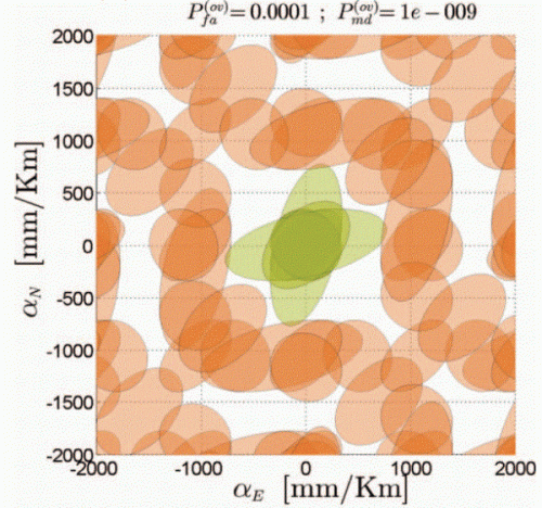
As a post-doc at the university of Munich, I investigated the use of a reference antenna array to instantaneously detect small ionospheric spatial gradients. These are small-scale irregularities of the ionospheric layer that cause delays in the GNSS differential observations even for small separations between antennas (baselines). Ionospheric gradients of magnitudes reaching several decimeters per kilometer have been observed. The detection of such small disturbances requires either using very large antenna arrays or exploiting the higher measurement precision of carrier-phase observations. These largely enhance the detection capabilities of an integrity monitor by providing higher sensitivity to small errors and biases, but are ambiguous by an unknown number of integer cycles. The primary consequence of the presence of integer ambiguities is the existence of multiple undesired acceptance regions, i.e. values of the ionospheric gradients that cannot be detected with a-priori defined probabilities of false alarm and missed detection, due to a partial or whole mapping of the bias/error into the integer domain. I have analyzed from a theoretical standpoint three integrity monitors, each designed to detect ionospheric gradients from antenna arrays spanning no more than several hundred meters. The first ionospheric gradient monitor analyzed is based only on pseudorange observations, the second only on carrier-phase observations, and the third exploits both observables . The monitors that use carrier phase measurements are characterized by largely enhanced detection capabilities with respect to the pseudorange-only monitor. The problem of multiple acceptance regions is tackled by designing several ionospheric gradient monitors whose acceptance regions do not overlap, and applying them simultaneously. This approach enables the correct detection of ionospheric gradients as small as 250 millimeters per kilometer with very stringent integrity requirements on small antenna arrays, with baseline lengths not exceeding 220 meters.
Read more here.
Test of general relativity with Galileo satellites
On August 14th, 2014 the first two FOC (Full Operational Capabilities) Galileo satellites Doresa (GSAT-0201) and Milena (GSAT-0202) were unfortunately injected in the wrong orbit due to a mechanical failure of the launcher. Instead of flying nearly-circular orbits with a semi-major axis of 29600 km, both satellites were injected in highly elliptical orbits, with an eccentricity larger than 0.2. This eccentricity was later reduced to about 0.16 with several orbital maneuvers, but it remains much larger than the nominal value of operational Galileo satellites’ orbits. A further reduction was not possible due to the limited amount of fuel onboard the satellites. The European Space Agency (ESA) is still presently assessing whether the two satellites can still be integrated in standard operations (2019) . However unfortunate, this mishap provided us with an unexpected opportunity to test the theory of relativity.
According to general relativity, the rate of a clock located at a position of higher gravitational potential is increased when compared to the rate of a clock situated in a region of lower gravitational potential. This is known as “gravitational redshift”, and it can be observed by directly comparing the readings of clocks placed at different heights. The most accurate measurement of this effect was provided by the Vessot-Levine rocket experiment Gravity Probe A (GP-A) in 1976: a hydrogen maser was launched on a sounding rocket to an altitude of 10000 km, and its frequency shift was tracked from ground during the entire ballistic trajectory. The experiment confirmed the predictions of Einstein’s theory to an accuracy of 1.4·10−4 (or 140 parts per million).
The eccentricity in the orbits of the two Galileo satellites Doresa and Milena bring them closer to the surface of the Earth at their perigee and further away at their apogee. In each orbital revolution the two satellites lose and then gain 8000 km in altitude, flying regions characterized by different gravitational potential. Each satellite carries four stable atomic clocks, two passive hydrogen masers and two Rubidium frequency standards, and in nominal operations one of the masers is designed as master clock, while the other units act as redundancies.
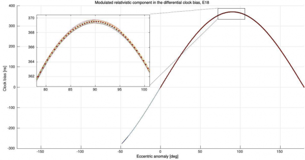
When observed from ground, the rate of these clocks varies according to their orbital position, with a sinusoidal-like variation of the gravitational redshift signature. Therefore, these two satellites nicely lend themselves as space-based, long-term experiments to increase the confidence on our measurements of the gravitational redshift effect, gifting us with two GP-A-like experiments per day! However, the Galileo satellites were not specifically designed to this scope in mind: the rate of the clocks cannot be directly measured but needs to be extracted by post-processing the same navigation signals that most of us use in our mobiles and satnav devices.
Since 2015, as part of a small team of scientists at the Technical University of Munich (TUM) and the Center of Applied Space Technology And Microgravity (ZARM) in Bremen, funded by the German Aerospace Center (DLR) and the European Space Agency (ESA) in the framework of a project named RELAGAL – Test of RELAtivity theory with GALileo satellites, I contributed to analyze the signals broadcast by both satellites. The relativistic signature can be observed very clearly in the signals tracked by stations from all over the world and processed in parallel by TUM and ZARM. The rate of the clocks in orbit varies continuously with respect to the rate of a clock on ground: this variation is observed as an oscillation with a period of one orbit and peak amplitude of 360 ns, introducing an identifiable signature on the extracted satellite clocks’ behavior. Consolidated preliminary results were presented at the end of 2018 and published in Physical Review Letters. These results confirm the predictions of general relativity to the same level of accuracy of GP-A. Processing of further data may surpass this historical result and provide the most accurate measurement of the gravitational redshift up to date.
Novel GNSS architectures with optical clocks and optical inter-satellite links
I am currently working on a project named ADVANTAGE (Advanced Technologies for Navigation and Geodesy), a collaboration between scientists at the Deutsches Zentrum für Luft- und Raumfahrt (DLR, German Aerospace Center) and the Deutsches GeoForschungsZentrum (GFZ, German Research Center for Geosciences) funded by the Hermann von Helmholtz-Gemeinschaft (HGF, Helmholtz Association of German Research Centers). Future generations of global navigation satellite systems are expected to take advantage of recent breakthroughs in optical frequency references and optical data communication technologies. Within project ADVANTAGE, innovative architectures for future navigation systems are being designed and developed for advancing satellite navigation, geodesy and time metrology.
Nowadays, the most widely used stable time references are atomic clocks, which lock to an atomic or molecular electronic transition in the microwave regime. Examples of such references are Cesium, Hydrogen and Rubidium atomic clocks. Optical clocks “shift” the locking from microwave transitions to optical (i.e. much higher frequency) transitions. The optical frequencies (THz) are then measured and/or transferred to microwave frequencies (GHz/MHz) with a device named “frequency comb”. Successful implementation of optical technologies earned John L. Hall and Theodor W. Hänsch the 2005 Nobel Prize in Physics. Optical clocks are capable of providing much higher stability, outperforming the current standards operating in the microwave regime by orders of magnitudes.
The basic operating principle of optical frequency references is the stabilization of a laser to a given optical frequency. Two different realizations of this principle are being tested and developed by DLR in this project: cavity-stabilized lasers and Doppler-free spectroscopy of molecular iodine. In the former approach, a laser is stabilized by using the resonance of a “cavity”, which is constructed with high reflectivity mirrors separated by a spacer, usually made of stable materials characterized by low thermal expansion. The spacing between the mirrors determines the resonance frequency to which the laser is “locked” (as c/2L, with c the speed of light and L the length of the spacer): when an integral number of wavelengths occupy the gap between the two mirrors, constructive interference occurs and a standing wave is created. Cavity-stabilized lasers are very stable in short term, but the locked frequency tends to ‘drift’ away over time. These units are then not directly used for generating a stable time scale, since the clock ‘rate’ would change over time, but can be exploited as a short-term reference for synchronization or for pre-stabilization before probing optical transitions.
The second realization being investigated is an Iodine clock. This is based on Doppler-free spectroscopy of molecular iodine at a wavelength near 532 nm, in which optical transition of iodine molecules are probed with a pre-stabilized laser. Such clock provides frequency stabilities far superior than any current atomic clock employed today.
Both cavity-stabilized lasers and Iodine clocks can be used in future GNSSs for providing enhanced synchronization between navigation satellites. Modern satellite navigation primarily relies on the broadcast of synchronized navigation signals from a constellation of satellites in Medium Earth Orbit (MEO). Cavity-stabilized lasers and frequency combs could be used in future constellations for timing the navigation payloads. The optical references can be perfectly synchronized by means of a chain of inter-satellite laser links. Laser communication terminals and optical transceivers are also being developed and tested by DLR in the framework of this project. Not only can the laser terminals support the synchronization between satellites, but will also enable laser ranging (target accuracy at micrometer-level) to improve orbit determination and provide high data-rate communication (target rate above 50 Mbps) to relay information within the constellation.
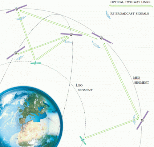
Both optical technologies — frequency references and laser links — will enable positioning and timing services with unparalleled accuracy. This modernized architecture is being designed in ADVANTAGE and takes the working name of Kepler. The fundamental idea in Kepler is to have a constellation of MEO satellites continuously linked via laser links, providing users with perfectly synchronized navigation signals. The MEO constellation is complemented with a limited number of low earth orbit (LEO) satellites. The LEO satellites relay information between different MEO orbital planes, support the necessary intra-system monitoring service, and contribute to the provision of a system time scale.
The inter-linked MEO and LEO segments will allow for a significant reduction of the ground segments used today to support and monitor current GNSSs: all activities normally distributed over large (usually global) terrestrial networks could be transferred in space, with key advantages in terms of integrity capabilities (the capacity of detecting, identifying and excluding faulty elements in a timely manner), signal-in-space accuracy, navigation signals monitoring, antenna calibrations, and system-level security.
This innovative architecture will also support a wide range of satellite geodesy applications. Examples are the provision of precise geodetic reference frames, gravity field sensing and modeling, earth observation missions, sea level monitoring and atmospheric sensing. All these aspects are being investigated in the project by scientists of the GFZ.
The project results will influence the future evolution of satellite navigation in general and of the European GNSS system in particular. The results are being transferred both to the academic world and to industries to ensure the utilization of the most promising options in future navigation systems and related applications.
Project website: https://hgf-advantage.de/